
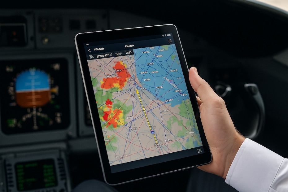
You strengthen your situational awareness with Jeppesen FliteDeck Pro by integrating live flight data, interactive charts, and predictive alerts into a single, intuitive interface. It brings together critical information—navigation, weather, traffic, and operational updates—so you can maintain focus and make faster, more informed decisions at every phase of flight.
This article explores how FliteDeck Pro improves your operational awareness from taxi to touchdown. You’ll see how its intelligent systems simplify complex airspace visualization, reduce cockpit workload, and help you stay ahead of changing conditions with precision and control.
What Is Jeppesen FliteDeck Pro and How Does It Work?
FliteDeck Pro is Boeing’s advanced Electronic Flight Bag (EFB) solution built for professional pilots and flight departments seeking smarter, real-time situational awareness. It integrates Jeppesen charts, weather overlays, traffic feeds, and aircraft data into a single, adaptive digital platform.
Instead of juggling paper charts and multiple devices, you operate within one synchronized ecosystem. The platform combines route data, performance calculations, and geo-referenced maps with real-time positioning and contextual information.
FliteDeck Pro uses “Smart Notes”—a feature that surfaces relevant alerts and procedural information based on your aircraft’s current phase of flight. Whether you’re climbing, descending, or taxiing, the system dynamically filters out irrelevant details so only the most critical information appears when you need it.
This targeted awareness helps you cut through noise and focus on execution—particularly during workload-intensive phases like takeoff, approach, and ground movement.
How Does FliteDeck Pro Improve Ground Situational Awareness?
Taxi and ground operations are among the highest risk segments for runway incursions. FliteDeck Pro tackles this challenge with Smart Airport Maps, displaying your ownship position over high-resolution Jeppesen airport diagrams.
The system continuously updates your aircraft’s position on taxiways, runways, and ramp areas, even in low-visibility conditions. You can see wingspan restrictions, hotspots, and active NOTAMs directly on-screen—information that used to require multiple paper references or manual lookups.
During taxi-out or taxi-in, these visuals make it easier to anticipate hold short points, identify correct turnoffs, and maintain compliance with clearances. For large or congested airports, it significantly reduces the risk of navigation errors that stem from disorientation or complex routing.
Another advantage is its compatibility with ADS-B traffic overlays. You can view nearby aircraft and ground vehicles in real time, giving you a live picture of traffic movement around the airport environment.
Key Ground Benefits of FliteDeck Pro
- Real-time ownship position displayed on airport charts
- Live traffic overlays via ADS-B for enhanced awareness
- Smart visual cues for hotspots, wingspan limits, and taxi restrictions
- Low-visibility routing assistance for safer surface operations
These tools allow you to maintain complete spatial clarity even in complex airport layouts, improving both safety and efficiency.
How Does FliteDeck Pro Support En Route Navigation and Traffic Awareness?
Once airborne, FliteDeck Pro becomes a dynamic flight visualization tool. The platform overlays TIS-B and FIS-B data to provide real-time traffic and weather updates directly on your navigation charts.
This means you can monitor developing storm cells, turbulence reports, and airspace restrictions without leaving your main interface. By layering this data over your route, you maintain a continuous mental model of surrounding air traffic and atmospheric conditions.
FliteDeck Pro also enables Tailored Enroute Charts—custom layers that operators can configure to show company-specific waypoints, restricted zones, or airspace rules. These personalized overlays streamline decision-making by aligning the digital map with your specific operating procedures.
As a result, you operate with heightened situational understanding, maintaining foresight across both strategic (flight planning) and tactical (in-flight adjustments) dimensions.
How Does Smart Notes Reduce Pilot Workload?
“Smart Notes” is one of FliteDeck Pro’s most innovative workload-reduction tools. It acts like an intelligent assistant that prioritizes relevant operational information in real time.
Rather than presenting every possible alert, Smart Notes uses location, flight phase, and procedural context to deliver concise reminders—like upcoming altitude constraints or runway condition changes. It’s an adaptive system that supports your flow without interrupting it.
By automating information filtering, it prevents distraction during critical phases. You no longer waste seconds searching through menus or flipping between apps. Smart Notes ensures that your attention stays where it should—on the aircraft and the environment outside the window.
In practice, this feature can mean the difference between catching a minor altitude deviation early and missing a critical clearance update in congested airspace.
What Features Enhance Decision-Making During Adverse Conditions?
FliteDeck Pro shines in unpredictable weather or congested airspace by centralizing all situational inputs. Its dynamic chart rendering adjusts based on operational conditions. For instance, it can highlight relevant taxiways and lighting configurations during low-visibility operations, improving your perception of runway alignment.
Weather layers display radar data, turbulence forecasts, and icing probabilities in near real time. When integrated with onboard connectivity, the system syncs with live flight updates, enabling you to visualize deviations, reroutes, or alternate airport options instantly.
For long-haul or high-density operations, it helps you make time-sensitive decisions quickly. You can analyze data visually instead of relying solely on text-based ATC instructions, leading to clearer, faster action under stress.
How Does FliteDeck Pro Integrate With Airline and Fleet Operations?
For fleet operators and corporate flight departments, FliteDeck Pro offers centralized control through data synchronization and enterprise integration.
Your flight department can push company routes, tailored enroute data, and standard operating procedures directly into pilot devices. Updates propagate automatically, eliminating manual data management. This ensures all pilots operate on consistent, current information.
The platform also supports ARINC 633-compliant flight plans, integrating seamlessly with major flight planning systems like PPS Flight Planning, ForeFlight Dispatch, and Collins ARINCDirect. This interoperability eliminates redundancy between planning and execution stages.
Ultimately, FliteDeck Pro bridges flight ops and cockpit environments, ensuring situational awareness extends across the entire operational chain—from dispatch to touchdown.
What Should Pilots Know About Training and Implementation?
To fully leverage FliteDeck Pro’s capabilities, you should treat it as a procedural instrument, not a convenience tool. Formal training and scenario-based practice help you internalize its layers and functions.
Most operators introduce it during recurrent simulator sessions, incorporating Smart Notes and airport map workflows into standard checklists. Pilots who train with realistic conditions—low visibility, runway changes, or weather diversions—gain the most practical benefit.
You’ll want to establish personal preferences too. Learning how to configure map layers, filter data, and toggle between en route and approach views can dramatically enhance usability during actual flight operations.
Proper setup ensures FliteDeck Pro becomes an extension of your situational scanning process rather than a digital distraction.
Are There Any Limitations Pilots Should Consider?
Like any EFB system, FliteDeck Pro’s performance depends on hardware, data connectivity, and subscription configuration.
Live weather, traffic, and tailored content require compatible data links (Wi-Fi, cellular, or satellite). Offline operation remains highly capable—but real-time overlays may be limited without connectivity.
Additionally, traffic awareness features like ADS-B rely on external broadcast availability. Some aircraft or vehicles may not transmit, meaning these systems complement but do not replace visual scanning and ATC monitoring.
Finally, keep displays decluttered. With so much data available, awareness can degrade if you overlay too many layers simultaneously. The best practice is to tailor your visual environment to the phase of flight—clear, relevant, and intuitive.
How does Jeppesen FliteDeck Pro enhance situational awareness?
- Displays ownship position on charts and taxiways
- Provides real-time traffic and weather overlays
- Delivers Smart Notes for phase-based alerts
- Integrates route, terrain, and airport data seamlessly
Fly Smarter, Stay Ahead
FliteDeck Pro redefines how you perceive and process flight data. By merging navigation, weather, and operational intelligence into a unified interface, it transforms decision-making into an efficient, intuitive process. You gain clarity, control, and confidence—qualities that define exceptional pilots in modern aviation.

Chrysilios Chrysiliou is a commercial real estate executive at RDPH Properties, Inc. with a diverse background in aviation and entrepreneurship. A former Greek Air Force Academy graduate, flight instructor, and flight school co-owner, he now leverages decades of strategic leadership to identify and develop high-value real estate opportunities.